


How a Camera on a Car Helped Detroit Challenge the U.S. Census
summary
- Detroit Street View began in 2017 to help with the redevelopment of the city's commercial corridors, but the program has since expanded to assist with a multitude of projects.
- The mobile mapping program played a vital role in challenging the 2020 Census population count, as well as revising subsequent estimates.
- Meanwhile, in Massachusetts, a police chief has undertaken similar efforts to help both the town and the police department.
When Detroit's enterprise GIS team first launched Detroit Street View (DSV) in 2017, they had no idea the mobile mapping program would help with the city's U.S. Census challenges — or inspire a Massachusetts police chief to take up a similar project.
At first, the goal was simply to capture images of the city's commercial corridors to support redevelopment. Using a GoPro strapped to a van, a volunteer from another department "drove really slowly down the commercial quarters" so city staff could see the state of those areas, says Tamara Fant, enterprise applications manager for the city.
Now, almost a decade later, Detroit has embraced a "map everything" approach, aiming to capture panoramic imagery and georeferenced data of every city street at least annually. "We're able to collect at a much larger scale than we could on just a human level," says Ted Schultz, enterprise GIS team supervisor for the city.
DSV has been leveraged for everything from assisting with emergency management and confirming the location of signage in traffic court cases to providing imagery for desktop assessments and maintaining the city's fire hydrants.
"We've never directly thought about this as we're intentionally building a digital twin, but it has some of those elements in it — the way that we're working on connecting this with our enterprise data environment and getting that repetitive picture of the city," Schultz says.
A Street-Level Perspective
The enterprise GIS team used funding from a Mayor's Innovation Grant to support the DSV project and to help purchase a Trimble MX2, a vehicle-mounted mobile mapping system. A few years later, they were given a grant from General Motors to purchase an upgraded system and vehicle.
The panoramic imagery they collect is uploaded to a crowdsourced platform, Mapillary, and after faces and license plates are blurred, the 360-degree images are made publicly available.
The system's updated light detection and ranging (LiDAR) technology has opened the doors to "actually modeling the environment," Schultz says. Pilot programs for several city departments, including public works, are underway.
Seeing Detroit through the perspective of someone in their car — rather than an aerial viewpoint — is beneficial for decision-making, Schultz says. "I think it's going to be more impactful as we continue these pilots and as we get more of these insights operationalized," he adds.

A screenshot from Detroit Street View (DSV) shows Michigan Central Station after its restoration was completed. The Station, previously abandoned, was given a new life as part of a 30-acre redevelopment project in the Corktown neighborhood. Image courtesy of DSV.
Counting the Benefits
An unexpected use of DSV, Schultz says, was its role in revising the 2020 Census and subsequent estimates.
The U.S. Census Bureau initially reported that Detroit's population declined by about 31,000 people from 2019 to 2020 and estimated it decreased by around 7,100 people from 2020 to 2021.
The city began reexamining those numbers after a University of Michigan and Wayne State University analysis found that the city's population was undercounted by at least 8 percent in several neighborhoods during the 2020 Census.
"We will probably never be able to calculate that opportunity loss in the number of developments and investments that didn't come our way, because who wants to invest in a city that is losing population?" says Trisha Stein, chief strategy officer for the city. "And we lost over 50,000 housing units in the 2020 Census, which is a huge, devastating blow and a hole that we are still digging out of."
DSV provided time-specific photo evidence in the city's legal and administrative challenges, as well as its population estimates submissions, Stein says. Before the challenges, the formula that the U.S. Census used to calculate population did not include reconstructions undergoing rehabilitation in the city. But the images DSV collected helped with a subsequent review of those homes.
Although a legal challenge remains, the U.S. Census Bureau now includes reconstructions as a category in its formula for determining population estimates across the country, which Detroit hopes will be helpful to other Rust Belt cities. And the 2024 U.S. Census found Detroit's population increased by almost 12,500 residents, including nearly 5,700 who were added retroactively between 2021 and 2023.
Schultz acknowledges there were dozens of factors that led to the city's success. "But it's really cool that we collected that data close to the Census enumeration date and that we've got this historic record of what something looked like from 2018 to today," he says.
Widespread Opportunities
About 700 miles away in Massachusetts, Wellesley Police Chief Scott Whittemore became frustrated with Google Street View's limited accuracy and began researching other options.
He stumbled across Mapillary in early 2025 and reached out to Schultz for more information. "He answered many of my questions and offered a lot of good advice," Whittemore says. "This allowed me to start at a very basic level with a cell phone mounted on the windshield of a police cruiser, and we started documenting the town on an unofficial basis."
To improve image quality and efficiency, Whittemore bought a GoPro Max 360 out of his own pocket and mounted it to his police cruiser. "I confess I spent a lot of my own time also capturing streets," he says. "My son loves to go on bike rides, so we got some areas on the weekend as we peddled all over town. He wasn't too embarrassed that his dad looked like a nerd with a GoPro on the helmet."
By the end of April 2025, the roads were almost completely captured, as well as the majority of the town's trails and green spaces. That May, Whittemore shared the results of the project through the city's traffic committee, which is run by the police and public works department.
"The benefits to the program are so widespread, it's hard to pin down any one thing," he says. The project allowed the town to update its sign inventory for the first time since around 2018, when two interns devoted many days to documenting every sign with a GPS device. With the help of artificial intelligence, they can determine how long a sign has been missing.
The images also helped Mike Thompson, the town's GIS manager, improve the accuracy of site plans and other maps. And while Whittemore knows mobile mapping isn't a typical responsibility of police departments, it has been incredibly helpful with planning operations.
Seeing how Wellesley has evolved over the years is a bonus for Whittemore. And that's something the Detroit GIS team also appreciates.
"It's not just the explicit applications — it's what we'll be able to know and how well we'll be able to show change over time," Schultz says. "We're comprehensively documenting the city regularly, which is basically impossible by any other means as far as I can tell."
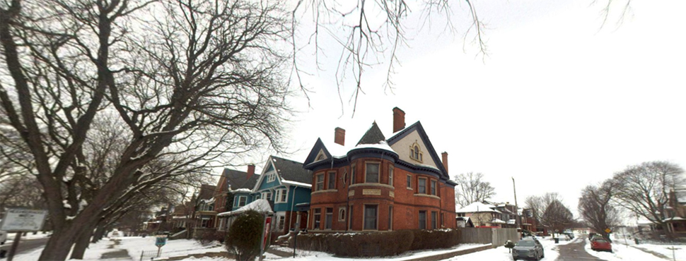
Top image: A screenshot from Detroit Street View (DSV) shows the intersection of Avery and Calumet streets in the historic Woodbridge District. Detroit uses images like these to show how neighborhoods change over time, during desktop assessments, and in its challenges to the 2020 Census. Image courtesy of DSV.
ABOUT THE AUTHOR