


Planning August/September 2015
A Rising Tide of Engagement
The profession leans in on climate change.
By James C. Schwab, AICP
It's official: Climate change and natural hazards are hot topics for planners — at least judging by session attendance at APA's National Planning Conference. Together, sessions on these topics drew nearly 3,000 attendees at this year's conference in Seattle. To be precise, the 17 climate-related sessions drew 2,231 participants, while six sessions specifically related to disaster topics drew another 730. Those 2,961 attendees compare with just 73 in two modestly attended sessions in 1995 in Toronto. What a difference two decades make in the planning profession.
To be fair, climate change was barely squeezing its way onto the public agenda in 1995, and the implications for planning were still sketchy. Even so, both Hurricane Andrew (1992) and the Loma Prieta earthquake (1989) were relatively recent memories back then, as were the massive Midwest floods (1993) and the Northridge earthquake (1994).
The planning profession had only begun to perceive its role in helping to address issues of hazard mitigation and disaster recovery, let alone climate change. An APA team had begun work on a Planning Advisory Service report on disaster recovery, but its work would not emerge until the end of 1998 with the publication of Planning for Post-Disaster Recovery and Reconstruction (PAS Report 483/484). Even by the early 2000s, total attendance at NPC sessions about hazards never reached 300.
Hurricanes Katrina and Rita, perhaps aided by the Indian Ocean tsunami, seem to have triggered a sea change. Granted, APA made more sessions available, 15 in all, but attendance rocketed to 915 at the 2006 conference in San Antonio. In the fall of 2005, I spent many hours in interviews with the news media discussing the implications of Hurricane Katrina. I can attest that not only planners, but the nation as a whole, was realizing that good planning had some relationship to the level of damage a community sustains in the wake of catastrophe.
Where we build, how we build — not only homes and businesses but critical infrastructure — played a huge role in the hurricane-related deaths of roughly 1,800 people and in displacing hundreds of thousands from their homes, many of them permanently. And the price tag — well in excess of $100 billion — made clear forever that a penny saved on mitigation earns a huge negative return when disaster strikes. (That same year, a National Institute of Building Sciences study concluded that a federal dollar spent on hazard mitigation saves about $4 in long-term damages, a figure that has been widely cited ever since.)
In recent years, APA has responded to the increase in interest with growing numbers of sessions on both climate change and disaster planning. Still, the 2015 NPC set new records.
It is harder to gauge interest at state chapter conferences, but in the past seven years, I have been invited with others to speak on these topics at state conferences in Texas, Mississippi, Tennessee, Iowa, Ohio, and New Jersey, as well as two regional conferences in the Midwest, and it always seemed clear that planners are tuning in, often because of recent disasters.

Integrating hazards into planning practice
Many communities are inadequately prepared for disaster and do not take hazard mitigation seriously enough in their routine planning. In the first decade of implementation of the Disaster Mitigation Act of 2000, it often seemed that communities prepared the required local hazard mitigation plans more to retain their eligibility for Federal Emergency Management Agency mitigation grants than because of local planning priorities.
In many communities, preparation of mitigation plans was assigned to emergency managers, not planners. However, few emergency managers are trained for public engagement, so public participation in hazard mitigation plans was often minimal. This state of affairs does little to build hazard awareness in the community. Worse, without a role in the process, planners in many such communities cannot bring their knowledge of land-use issues to bear in a way that would facilitate implementation of some of the best hazard mitigation solutions, such as better siting and infrastructure development decisions.
That seems to be changing. In May 2010 APA published PAS Report 560, Hazard Mitigation: Integrating Best Practices into Planning. Reflecting and incorporating the work of some of the best hazard mitigation planning experts in the nation, it discussed how communities can integrate hazard mitigation priorities in all types of local plans, including subarea and functional plans, and in the implementation and budgeting tools that can help make resilience a reality.
The report noted that 10 states required some type of hazard-related element in local comprehensive plans in 2010 and that some cities and counties in other states found ways to make it happen even without such a mandate. That year, too, largely as a result of the 2008 floods that swamped cities like Cedar Rapids, the state of Iowa enacted its Smart Planning Act, requiring that hazard mitigation elements in plans be prepared "with reference to the local hazard mitigation plan prepared for FEMA."
FEMA sponsored the APA study. Over the last five years the agency has issued a steady stream of national and regional guidance aimed at promoting such plan integration, using case studies to demonstrate the beneficial impacts and generating momentum toward this goal within the planning community. FEMA Region 10, based near Seattle, has produced its own set of state and local examples of successful integration of hazard mitigation into local plans. Region 8 (Denver) has promoted the idea in the Rocky Mountain states.
Colorado's Department of Local Affairs this January released a request for proposals to create guidance unique to Colorado community circumstances on best practices in achieving such integration. Following that lead, the small mountain city of Manitou Springs (pop. 5,300) in May requested proposals for a new comprehensive plan that would incorporate a hazard mitigation plan meeting FEMA requirements that would also serve as an element in the comprehensive plan. The city is using a planning resiliency grant from DOLA to finance the effort. The RFP notes that the city in 2013 "endured a series of flooding events that caused injury and loss of a life, and significant damage to the built and natural environment and economy."
It was hardly the only city in Colorado to suffer such a wake-up call. Across the Front Range in September 2013, numerous communities, most notably the small town of Lyons, were inundated after thunderstorms produced high precipitation and floodwaters racing down mountainsides. In many cases, prior wildfires had already burnt forests and diminished the capacity of hillside soils to absorb the rain. The bottom line is that in Colorado and many other places, a shift is occurring toward more integrated approaches to hazard mitigation than was common even in the recent past.
40 Years of Disaster Research
In 1976, the University of Colorado-Boulder opened the Natural Hazards Center, a pioneer in studying hazards and disasters. In July, James Schwab, AICP, manager of APA's Hazards Planning Center, joined fellow experts in reflecting on four decades of knowledge in the field. Watch their plenary presentation from the Annual Natural Hazards Research and Applications Workshop.
Hunt for data
Even as they do this, though, some communities are beginning to wrestle with a knottier challenge: integrating data concerning climate change and its associated hazard impacts into their local planning process. If it makes sense to use the comprehensive planning process to address long-term hazard mitigation needs, what about the additional concerns engendered by rising temperatures and sea levels, more volatile weather extremes, or such cascading impacts as those suffered in Colorado?
And where do states and communities get the best data to anticipate how hazard mitigation programs today can enhance resilience in the face of climate-induced events over the next half century? It is worth noting that most of the built environment is intended to last at least that long, particularly new homes and major office complexes. Will they be able to withstand the projected weather conditions of the mid-21st century? If so, what standards need to be in place now to make that happen?
Fort Collins, Colorado, has begun to think about such vexing questions. In a presentation to the Flood Mitigation and FloodProofing Workshop of the Association of State Floodplain Managers, in October 2014, just one year after the Colorado floods, Brian Varrella, an engineer and floodplain manager for the city, noted that flooding had been severe in part because of the hardening of the soil during previous wildfires, which themselves could be connected to high heat and drought conditions that prevailed in the state even earlier.
Varrella told the audience that we need to learn to see these as cascading, related events that require regional cooperation at a watershed level and much greater diligence at the local level. And clearly, there is a distinct element of adaptation to climate change that must enter the planning equation. We cannot treat these phenomena in isolation from each other.
In California, coastal Monterey County is examining climate change impacts on its hazards profile in an update of its local hazard mitigation plan. County planners have been using tools from the Digital Coast program at the National Oceanic and Atmospheric Administration, as well as assistance from Cal-Adapt, the climate change research program of the California Energy Commission. The website for the county's Office of Emergency Services states that the plan incorporates "new information to help address the potential long-term effects of climate change and sea level rise."
One of the most prominent examples of a major city pursuing such integration is the Disaster Preparedness and Planning Project of the city of Baltimore, which completed its plan in October 2013. Although many cities have developed climate adaptation plans, sometimes as part of a larger climate action plan, Baltimore decided that it would incorporate its climate adaptation plan into its all-hazards mitigation plan under the Disaster Mitigation Act. The city describes the resulting combination as "an effort to address existing hazards while simultaneously preparing for predicted hazards due to climate change." The rationale for the plan's vision statement says: "Integrating hazard mitigation planning, which focuses on past events, with climate adaptation planning, which focuses on what will likely happen in the future, offers a positive, win-win solution for Baltimore City." Every hazard that may be introduced or exacerbated by climate change is incorporated into the analysis of existing hazards in order to achieve a more forward-looking strategy.
Baltimore is the exception — for now. FEMA wants to make it more typical, this year by updating its Hazard Mitigation Assistance Guidance to promote climate change adaptation. The steps include incorporating sea-level rise in the calculation of benefit-cost analysis for coastal mitigation projects and preparing for evolving flood risk. To sustain this momentum, it is critical that technical assistance to smaller communities on climate-related issues be maintained and expanded.
This includes not only direct federal and state guidance and grants, but dissemination of usable information through academic and nonprofit sources. In fact, planners' access to such data and how best to use it was the topic of the very first session in the climate symposium at the APA conference in Seattle. That session was one of the most heavily attended.

Recovery and resilience
Hurricane Sandy provided a brutal wake-up call for many communities in the Northeast. It also reminded us that the best preparation for disaster recovery is to make resilience a central aim of planning — locally and regionally. It is impossible to know when a community's moment of truth will come, but procrastination clearly isn't a viable option.
Sandy made a heavy impact because it struck at the most densely developed strip of coast in North America. The region also contains profound variations in governmental capacity, from New York City to small boroughs on the Jersey Shore with a year-round population of under 2,000. In both cases, opportunities for relocation away from hazardous areas were severely constricted. That, in turn, had profound implications for improving local resilience in the face of disaster. (See "Hurricane Sandy's Wake-Up Call," February.)
To planners, resilience is both new and very old. We have been trying to anticipate and prepare communities for the future since planning emerged as a profession a century ago. But recognizing natural disasters as part of that preparation is much newer, and explicitly using resilience as an organizing concept for how we approach that task is newer still.
Although widely used today in fields like engineering and the social sciences, the term largely originated in ecology, referring to an ecosystem's ability to restore itself after a major impact, such as a wildfire or coastal storm. As extended to urban systems, the term refers to our ability to quickly and efficiently rebuild but also adapt, largely by learning new lessons. Today, many of those new lessons involve adapting to and learning from a changing climate. Whether Sandy can explicitly be linked to climate change is less important than understanding it as a symptom of potential future events, and making the necessary adjustments to reduce the vulnerability of the built environment.
In 2013, the final report of the Hurricane Sandy Rebuilding Task Force, led by HUD Secretary Shaun Donovan, aimed to shift federal policies on post-disaster recovery assistance to address these questions. The report emphasized green infrastructure as a way to ameliorate the impacts of disasters, while recognizing that it could not provide all the answers. The task force recommended the development and use of appropriate tools to better incorporate sea-level rise into future risk assessments. That means planners can expect more interaction with agencies like NOAA, which have the data needed to fashion appropriate solutions.
The Sandy experience also prompted a lot of soul searching at HUD over the use of its Community Development Block Grant-Disaster Recovery (and other resources) to facilitate recovery. The immediate result was the 2013 Rebuild by Design competition, leaning heavily toward architectural and engineering solutions, which sought new ways to introduce resilience to Sandy-affected communities.
But that was just the beginning of the evolution of policy inside HUD, which last fall announced the $1 billion National Disaster Resilience Competition, incorporating many more planning and community development considerations into the equation. The competition was open to all states and some designated counties and municipalities that had experienced disaster declarations between 2011 and 2013, with money from the Sandy supplemental appropriations.
Phase I pushed those applicants to think in terms of broad strategies for resilience with an eye to the needs of underserved populations, a challenge for many that were used to more traditional project-based competitions. Winners of the Phase 1 competition were announced in June, at which time those moving to Phase II could outline more specific projects in line with their broader Phase I goals. Depending on the leanings of future administrations, this approach may be a sign of what communities can expect from federal policy makers in the future.
Post-disaster recovery
Meanwhile, at the end of last year, APA released Planning for Post-Disaster Recovery: Next Generation, PAS Report 576, which revisited the subject of recovery. The report echoes an emerging theme consistent with FEMA's National Disaster Recovery Framework: the value of preplanning for recovery.
Florida in 1987 recognized this idea with a statutory requirement, rescinded under current Gov. Rick Scott, that communities develop a post-disaster redevelopment plan to lay out policies for addressing recovery ahead of future disasters. Next Generation details the rationale for doing this with two primary points: one, that communities can at least establish the governance structure for managing recovery, so that officials can assume their proper roles in recovery and even prepare for them before disaster strikes; and two, that some broad policy decisions regarding recovery goals can be established even before a specific pattern of damage from a real disaster becomes known. That allows the community to use post-disaster recovery planning to apply those goals rather than spending valuable time debating them.
The actual process will usually be far more complicated, but this framework seems to be catching on. Hillsborough County, Florida, has recognized that the Tampa Bay region has been lucky in avoiding a direct hurricane strike over the past half century, but it also sees that the next disaster is coming. Among other measures, it has adopted in its PDRP a policy of Priority Redevelopment Areas, essentially steering post-disaster redevelopment to prescribed less hazardous zones within the county and away from more vulnerable areas. The policy has numerous nuances related to issues like sunk costs in infrastructure, but the basic framework is clear — and remarkably bold.
Where do these plans belong? Planners can be thinking about integration into the larger planning context, about incorporating hazard mitigation into the recovery process, and the recovery process into the comprehensive plan, among other elements of more holistic planning. It's a brave evolving world.
The next generation
What does all this tell us about the training needed for planning students and emerging professionals? First, the academic community may face some serious challenges in making planning education relevant to some of the biggest dilemmas their students may eventually face. A Hazards Planning Center review of the course offerings of accredited urban planning programs in the U.S. shows that less than one-third of graduate programs offer courses related to either natural hazards or climate change, or both. For undergraduate programs, the number is closer to one-fifth.
Some of the gap may reflect the research interests of planning faculty. If so, perhaps the Autumn 2014 issue of the Journal of the American Planning Association, devoted to disaster recovery and guest edited by Karl Kim (University of Hawaii) and Robert Olshansky, FAICP (University of Illinois), presages some movement in this direction. It is fair to say that the volume of planning literature related to hazards and climate change has been growing steadily and is unlikely to diminish. There is an audience.
Also clear is that the planning profession, both in academia and in practice, has never had the option of falling seriously behind the times. If planning fails on this issue, so do our communities. Despite the political volatility of climate change at the moment, one need only remember the political backlash engendered by the initially muddled response to Hurricane Katrina, or the policy changes wrought by Hurricane Sandy, to realize that major change is just a disaster away.
Jim Schwab is the manager of APA's Hazards Planning Center. As adjunct faculty, he also teaches planning for disaster mitigation and recovery at the University of Iowa School of Urban and Regional Planning.
Resources
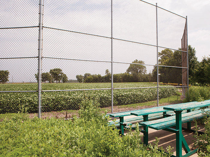
Image: Top — Tornadoes are devastating — but Greensburg is making something special rise from the rubble. Among the structures built after a Category 5 tornado hit the city on May 4, 2007, is the 5.4.7 Arts Center, dedicated to the visual and performing arts. It is the state's first LEED Platinum building. Art has become an essential part of the city's social and economic redevelopment plan. Photos by Mario Tama/Getty Images. Middle — Valmeyer, Illinois, is the little town that could. After the massive Mississippi River flood of 1993 destroyed 90 percent of the town and swamped surrounding farmland, Valmeyer used federal funding to relocate from the river bottom to a bluff about two miles east and about 400 feet higher. Photo courtesy Rockhill+Associates. Bottom — A former baseball field has become a cornfield. Valmeyer, Illinois, is slowly building back to its pre-flood population of 900. Photo courtesy Rockhill+Associates.