Planning August/September 2020
Right-Sizing Transportation Investments
With fewer resources because of COVID-19, cities are turning to an emerging practice that offers practical techniques to recalibrate their existing transportation infrastructure with economic realities and social returns.
By Chandler Duncan and Michael Brown, AICP, PE
Everything ever built was once considered "the right size" by those who built it. But what is right for one moment in time can be wrong for another or can have hidden costs or unexpected consequences: Demand for a roadway may turn out to be much lower than anticipated or decline for many years after peaking. A community's land use and economic base may evolve differently than expected. What made sense for a previous generation might become costly, inefficient, or even dangerous going forward. Or in some cases, builders at the time simply might not have had enough information to make a wiser investment.
Regardless of the cause, time tends to reveal situations where the cost of maintenance or upgrades is too high relative to the benefits gained. The result: regions and cities are stuck with infrastructure portfolios that they can't afford, that don't fit the current and future needs of their communities, or both.
As planners look toward recovery from COVID-19 economic impacts, this issue will become even more challenging. Regional and local governments will be under increased pressure to make better use of scarce money, land, and other resources. Fortunately, there are ways to achieve this, including a relatively new practice and way of thinking about transportation infrastructure called "right-sizing."
We recently led the creation of a guide on this emerging planning practice for the National Cooperative Highway Research Program, Right-Sizing Transportation Investments: A Guidebook for Planning and Programming (NCHRP Report 917). In addition to describing the right-sizing process and policies and providing case studies about where it's been applied successfully, the report includes practical techniques and tools to make the best and highest use of space within the transportation right-of-way, achieve the best possible performance for economics and mobility, and create adaptable transportation systems.
We've seen again and again how right-sizing tools and approaches — a few of which we cover in this article — can generate new types of transportation projects to support economic recovery and performance, especially in cases of limited resources.
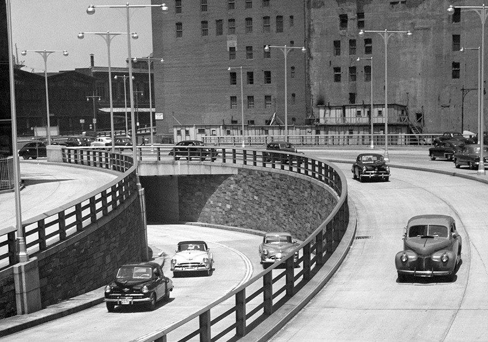
The roadways that dazzled 1940s drivers aren't always a good match with modern transportation priorities. Photo by George Marks/Retrofile RF.
Right-sizing 101
Right-sizing focuses on the realization that today's sources of value in existing infrastructure assets (and the land they occupy) may not be fully realized, perhaps because of changes in the underlying markets they serve since the assets were built, or because of a limited understanding of their value to other stakeholders by the owning and building agencies.
Right-sizing transportation infrastructure offers a framework for planners to discover when certain aspects of the system do not match well with existing or emerging needs. Once a case has been made, the goal is to settle on a strategy that represents the "highest and best use" of the available right-of-way and funds based on a weighting of stakeholder objectives.
Right-sizing sounds a lot like downsizing, as in reducing the number of lanes on a highway or replacing underused freeways with at-grade boulevards. While reducing underused pavement and bridges in favor of other uses, or to reduce life-cycle costs, can be an outcome, right-sizing is not about reducing infrastructure. It is about better fitting infrastructure to current and emerging sources of value.
Using right-sizing techniques, stakeholders in a rapidly growing area can conclude that the right size for them involves increasing the number and size of their roadways.
But instead of traditional auto-oriented design, they may prefer to see their new roads designed in a way that will catalyze walkable densities or land-use diversity along new corridors. Right-sizing methods allow planners to evaluate the business case from more points of view than before (considering return on investment to state, municipal, and private owners, users, and decision makers).
Right-sizing also entails evaluating in economic terms the relative efficiency of more policy-oriented options for saving space and money, such as congestion pricing, eliminating parking requirements, or creating "free at five" transit programs in congested corridors. It can also involve economic analysis of qualitative objectives, such as placing a priority on social equity and evaluating that within an economic framework against more traditional objectives.
Right-sizing partnerships
Partnerships are critical to an effective right-sizing process. While a state department of transportation or municipal government may technically own the right-of-way, different stakeholders see different opportunities for value capture, and may even be willing to invest their own funds for specific things.
For example, the state transportation department may govern an underutilized freeway that isn't causing immediate problems because short-term maintenance costs are reasonable and it meets statewide speed and safety goals, but the municipal planning department may see it as blocking neighborhood connections, consuming more land than it needs to, and hindering redevelopment opportunities. The city may be willing to finance a portion of the reinvention based on expected revenues from new development. Likewise, property owners in a business district, if queried, may be more than willing to invest in developing and maintaining complete street amenities to help boost their property values. Yet neither the city, state department of transportation, nor transit agency is aware of that potential, nor have they organized a mechanism for their financial participation.
With that in mind, effective right-sizing initiatives seek to expand partnerships between those who have situational intelligence (information and analytical capability), those with authority (ownership or statutory power), and those with resources (public and private funding, land, or other means) to achieve right-sizing objectives. In effect, successful right-sizing leverages all sources of value and funding opportunities across all stakeholders (not just the owning and investing entities).
One of the practical tools available in the free guidebook Right-Sizing Transportation Investments is the Stratified Return on Investment Calculator. It allows planners to engage different owning, funding, deciding, and using entities in an assessment of potential sources of value associated with a transportation asset (including land) to determine specifications for its true "right-size" characteristics.
Based on this assessment, planners can identify which stakeholders have the strongest business case for investing in a change to the infrastructure, the magnitude and type of change warranted, and where and how right-sizing payoffs are likely to occur.
COVID-19 recovery
Federal, state, and local policy response to COVID-19 is posing significant challenges to governments that rely on sales, income, and gas-tax revenues to preserve existing infrastructure. The need to maximize the economic return for each dollar of outlay to preserve and adapt infrastructure is an area of urgent and immediate significance.
As the economy recovers in the post-COVID society, households and industries will be using businesses, institutions, and transportation systems differently than before. Where and how businesses can afford to rebuild, as well as where and how households choose to live and travel, will pose a new dynamic on land and transportation portfolios.
Right-sizing techniques not available in previous economic recoveries can help planners identify sources of value, prepare for different recovery scenarios, and make the business case for how to allocate scarce funds in the months and years ahead.
Chandler Duncan is vice president of Metro Analytics. Michael Brown is the company's founder and president. Duncan served as principal investigator for the NCHRP 917 right-sizing guidebook, while Brown led many of the design-related aspects of the guide.
7 Ways to Right-Size Transportation Corridors
A host of techniques and solutions can be part of right-sizing strategy when developing projects and scenarios at the corridor, community, or state level. Here are a few that may prove valuable to planners seeking to adapt their infrastructure footprint for maximal efficiency across many objectives.
1. Corridor Preservation
Since World War II, transportation networks have been "dendritic," meaning they have more winding streets and cul-de-sacs than through streets. The result is that both short trips and long trips all funnel to the same few through-streets.
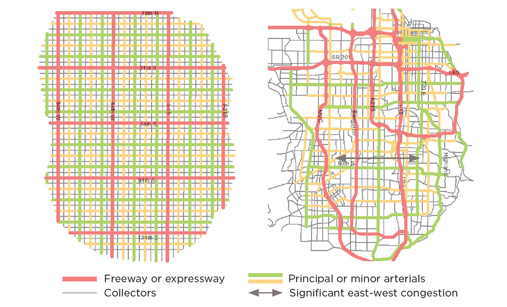
The Institute of Transportation Engineers (ITE) has suggested that emerging areas would do well to preserve corridors for a freeway, tollway, or expressway every five miles, an arterial every one mile, and a collector at least every half mile. This is fewer through-streets than in historic grids, but also significantly more than many of today's suburban areas. Thus, one right-sizing technique is for communities to map how they might have looked with this ITE grid versus how they actually look or are about to look in emerging portions of their region.
Instead of designing to a horizon year, only to find you didn't preserve what was needed for the next horizon year, a good right-sizing technique is to create a master architecture for build-out, then select phased projects from that. A community can elect to preserve less space for expressways and more for alternative modes but should always aim for something that can function well at build-out. This technique allows planners to see where their network lacks resilience and identifies corridor preservation opportunities amidst emerging development.
Right-Sizing in Salt Lake City
This ITE grid shows how Salt Lake could have evolved versus its existing and planned arteries. Some of the worst congestion in the state, indicated by the arrow below, is where the grid lacks both expressways and collector streets.
Source: Metro Analytics, NCHRP Report 917.
2. Grayfield Revitalization

Photo by James Tung, iStock/Getty Images Plus.
Many commercial arterials are lined with a hodgepodge of uses, and they lack the street trees or multimodal features that help stabilize markets. Over time, grayfields emerge as residents and businesses see the crumbling hardscape and decaying properties and move to where the grass is literally greener. This leaves the region with duplicative infrastructure, increasing aggregate life-cycle costs.
When grayfield decay sets in, an important right-sizing concept is to create conditions that will make them desirable again. Form-based codes and loosening density and parking requirements can contribute to such strategies. However, right-sizing can include remodeling the roadways that serve grayfields, as it is hard for the market to create walkable development if the roads are perceived as ugly and unwalkable.
3. 'Backage' Roads
Land uses along arterial corridors tend to start out low density, but eventually they need a mechanism to transition to higher density to avoid decay. Key to that transition ability is creating a network of connected streets from the beginning, some of which will parallel the arterials as backage roads that run behind development (as opposed to frontage roads that are between development and a larger arterial or expressway).
Backage roads ideally will be within 300 to 600 feet of the arterial. These can usually be collector roads, built incrementally, so long as the end result offers continuity for local circulation that is not dependent on the arterial.

Default network versus backway support. Source: Metro Analytics, NCHRP Report 917.
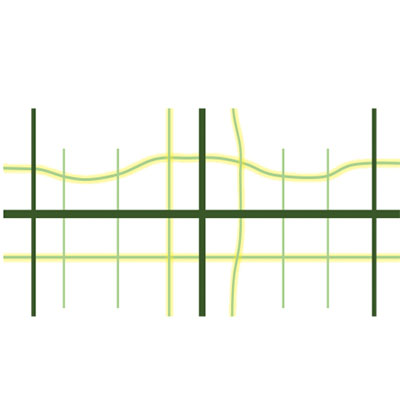
Default network versus backway support. Source: Metro Analytics, NCHRP Report 917.
4. Transforming 'Stroads'
A significant impediment to rejuvenating grayfields is the auto-oriented nature of many suburban highways. The term "stroad," or a street-road hybrid, coined by Charles Marohn, founder of StrongTowns.org, seems to describe such highways well. A street is reminiscent of historic Main Streets — the foundation of yesteryear's economically vibrant and walkable places. A road is where high speeds are needed for traversing long distances. Marohn says both streets and roads have an appropriate place in urban fabrics, and we agree. However, the stroad is an awkward hybrid that tries to serve both local economics and high-speed vehicles but does neither job very well due to complex signals, serious congestion, and excessive hardscape that contributes to adjacent property blight.
Technology can help planners right-size their use of space by considering the opportunity costs of each foot of a given cross section. For example, www.StreetPlan.net is a free utility developed by our company, Metro Analytics, that makes it easy for anyone to design complete street cross sections using best-practice guidance.
BEFORE: The speed limit is 35 mph, but speeds commonly exceed 45 mph. Congestion and signals can result in actual speeds of 18 mph:

Source: streetplan.net.
AFTER: Speed limit is 5 mph slower, but average congested speed is 20 mph. The slower maximum speed actually means traveling faster on average due to what we call Placemaking Alternative Intersections. (Learn more at InnovativeIntersections.org.):

Source: streetplan.net.
5. Trip Length Analysis
Many arterials were built at a time when most of their trips were quite long and warranted high-speed design. But over time as those corridors diversify land uses, neighborhood-oriented trips begin to dominate, and high speed is less critical. But if we look only at traffic counters, which might report "30,000 average daily traffic," it is hard to tell that anything has changed because a counter cannot distinguish between a long or a short trip. A good exercise is to find corridors where trip lengths are or will be quite short due to emerging land uses. These may be good candidates for traffic calming and investment in active modes.
Trip Lengths Can Change Over Time
Trip lengths count. A traffic counter may still measure "30,000 vehicles per day," and without knowing the trip length we might assume there is no market for walking, biking, or reducing vehicle speeds to safer levels.

Source: Metro Analytics, NCHRP Report 917.
6. Revenue/Expense Analysis
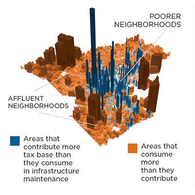
Expenses exceed revenues in Lafayette, Louisiana. Source: URBAN3, StrongTowns.
Understanding the relationship between infrastructure cost and the value of activity served is central to right-sizing. The revenues for infrastructure are generated from economic activity. However, it can often be unclear which land-use situations consume more in life-cycle costs than they produce in revenue.
By considering transportation costs in relation to economic activity served, planners can pinpoint opportunities to form right-sizing partnerships to better align transportation costs and performance objectives with economic sources of value.
7. Pedestrian Crossings
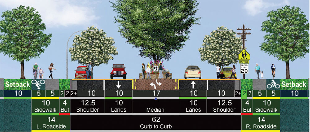
In Utah, a junior high student was killed while crossing a high-speed street in front of his school after the crossing guard had left. Schools and their playgrounds are magnets for kids on weekends and at random hours, and there is a strong argument for designing more for safety than for speed at these key crossings.
By planting trees in the median and shoulders, narrowing lanes, encouraging on-street parking, and possibly using raised crosswalks, it is easy to send a message to drivers that they should always be extra cautious at this location.
It seems counterintuitive, but making it tighter and harder to see actually makes crossings safer, because drivers sense that they must slow to safe speeds.
Actual speeds in the school zone average 40–45 mph when lights are not flashing, but with traffic calming (below), drivers will slow down at all times:

Source: streetplan.net.
Source: streetplan.net.


